

It is very important for homes and dachas to have water. Some lucky people can connect to the centralized water supply, but most have to find their own source. About how to find water on the plot yourself, with your own hands and will be discussed further.
文章内容
Aquifers and their occurrence
The structure of rock occurrence is very heterogeneous. Even on the same site at a distance of one meter “pie” – the composition of layers and their size – can differ significantly. That is why it can be so hard to find water on the site, you have to drill several wells to find a normal aquifer. There are three main aquifers:
It should be said that it is not difficult to find on the site topwater. Knowing some features of the vegetation, having checked some points, you will determine the location of the water carrier with a fairly high accuracy.
With the sand aquifer is much more difficult – the depths are serious, we have to focus mainly on the location of wells-wells in the neighbors, well and not some indirect signs.
Find artesian water on the site can be found only with the help of test drilling. Help can help maps of aquifer occurrence. Since 2011 in Russia, they are publicly available (without payment). To get a map of your region, you need to send an application to ROSGEOLFOND. You can do this on their official website, or you can download the forms of the required documents, fill them out and send them by mail (with return receipt).
How to find water on the plot with the help of folk methods
There are quite a few folk ways to find water on the plot. You can believe in them, you can not believe, but on average, the percentage of hits – 70-80%, which is not lower than the “scientific” methods, so it is definitely worth a try. These methods require some time and attention, but they are free (if you look for water on your plot yourself), so they can be combined – test several methods, and dig/drill at the point where their readings converged.
Pay attention to plants
This point makes sense only if the site is not developed, but “populated” with wild plants. By where and what plants grow, it is possible to determine the depth of the water table quite accurately.
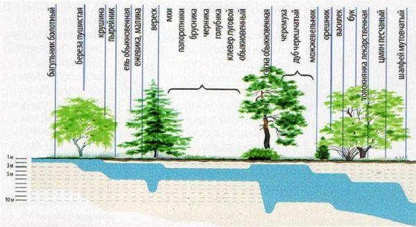
All you need to do is to walk around the site, look where it grows, near the found plants to put milestones on which you can indicate the possible depth of water. The table shows a list of plants, which can be used to determine the presence of water at a particular depth.
| Indicator plant | Depth of water table |
|---|---|
| Hornwort, marsh rosewort, downy birch | 0 – 1 м |
| Sandy reed, sweetgrass, wheatgrass, | 1 – 3 м |
| Reed, elk, sarsazan, spruce, blackberry, raspberry, black poplar | up to 5 m |
| Artemisia mellifera, shining chia, heather, common pine, bird cherry, petiole oak, | up to 7-8 meters |
| Naked licorice, sand wormwood, yellow alfalfa (up to 15 m), juniper, hazel, cornflower, bearberry, bearberry, beech. | 3-5 to 10 meters |
There are several species of trees in the table. We are not talking about arrays, but about single plants, maybe about a small group of plants that “cluster” in one place. In the case of herbaceous plants it is the opposite – they are not single specimens, but glades occupying a certain area of soil.
Use of frames
On a long-developed plot, it will not be possible to determine by plants where the water is located. Here it will be necessary to apply other methods. One of the most common and giving a high probability – search with the help of frames – aluminum wires bent at an angle of 90 °. This method is also called biolocation. You take two pieces of wire 30-40 cm long. A piece of 10 cm long bend at right angles.
To “readings” were more accurate, short pieces are inserted into tubes made of thin branches of tree-like elderberry. In the cut elderberry branches, the core is removed and a bent wire is inserted inside. The ends of the wire should move freely.
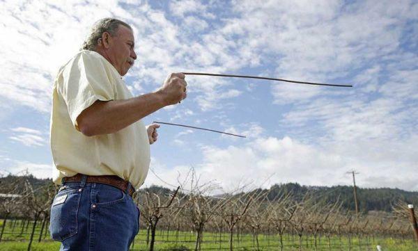
Taking the frames in both hands, the ends of the wires are spread in opposite directions (by 180°) and with them walk around the plot, observing their condition. Somewhere the frames will come together, somewhere turn to one side (to the right or left – according to the water flow). These movements are used to determine where the water is.
If the frames have come together (their ends have moved to some angle), water is in this place. Walking further you will see that the frames have separated again – the aquifer is over. Repeat the maneuver from different directions and points, so you can localize the location of the aquifer. If during the return pass both frames came together – you have determined the place where you need to dig a well or make a well. If the frames deviated to the right or left, you need to go that way and look for a place where they will come together again.
If the frames are motionless – there is no water on the site or water carriers are located very deep.
Using a vine (wooden slingshot)
Find water on the plot can be found with the help of a slingshot made of wood. It is necessary to find two branches that grow from one point. The branches should be thick, at least 1 cm, even. Try to find them of the same thickness. They should be cut off with a piece of the trunk (15-20 cm) on which they grew. A large slingshot should turn out.
Leaves are cleaned, the thin ends of the twigs are cut off, leaving at least 40 cm on each side of the “fork”. The branches are bent sideways to make an angle of at least 150°, fix them in this position and leave them to dry. The wood may not be completely dry, but the angle must be preserved.
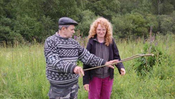
The dried vine is taken by the ends of the fork, holding it horizontally at shoulder level. In the place where there is water under the ground, part of the trunk will bow to the ground. In this place it will be possible to dig a well or drill a well. If there is no deviation – there is no water on the site at a shallow depth.
Determining the amount of water in the underground source
In addition to finding water, it would be good to determine its volume. Approximately they can be estimated with the help of clay pots and silica gel. Clay pots are taken, silica gel is poured into them, the neck is tied with cotton cloth. Packed pots are weighed (the weight can be written on the pot itself). The prepared shells are buried in places where water is supposed to be found and left for a day.
A day later, the pots are dug out and re-weighed.
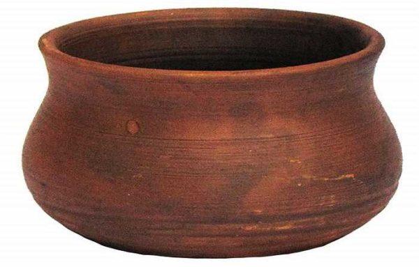
That pot, which has gained more weight than the others, and marks the vein with the largest amount of water.
Finding water – observing nature
Finding water on the plot can be done simply by observing nature. You may have noticed that in some places the fog is thickest. At times, it even resembles a river – winding its way in some direction. At such points, groundwater is usually closest. You should also look at the amount of dew in the morning. If in places where the fog was particularly thick, it is more, then there is definitely water there.
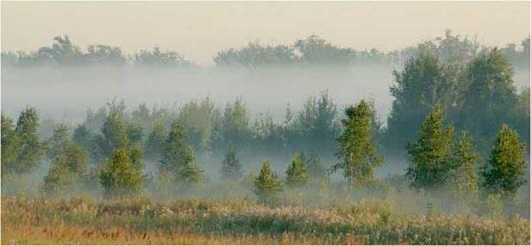
What else can help you find water on the site is observing insects. Warm windless evenings, often the midges gather in clouds or pillars. And they are located in certain places. Under the places where insects congregate, there are usually water sources. If you examine the ground in that place and do not find ant nests, then water is really there – ants over water do not make their nests.
How to determine the level of groundwater
You can roughly estimate the depth of the water table by the plants growing above it. As you can see from the table above, certain types of plants feel fine if the water is neither above nor below a certain depth. This is how you can roughly estimate how deep the water is.
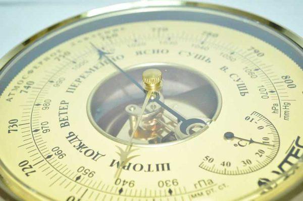
For areas where there is a natural body of water nearby – a river, a lake – you can determine the depth of the ground water with an accuracy of up to one meter. To do this, you will need a barometer. With it you go down to the water itself, measure the pressure. Then you go to the supposed source of water and measure the pressure there. The difference is usually expressed in tenths and each tenth (0.1) is equated to a meter of depth. For example, the difference in measurement is 0.7 mmHg. This means that the water is at a depth of 7 meters.
What else can help you find water on the plot? Communicating with neighbors who already have a well or borehole. From them it is desirable to find out where they drilled/digged, how many times, a lot of water or not, at what depth is the water mirror, what quality it is. By the location of all the nearest successful and unsuccessful attempts at neighbors, you can determine with a fairly high degree of probability where your water is located.

")


